
Political ecology and artificial intelligence
When the forest enters the model
Artificial intelligence can improve wildfire detection and response, but it cannot replace the climatic, territorial and social transformation required by an increasingly flammable Europe.
Artificial intelligence, wildfires and the politics of landscape in a burning Europe
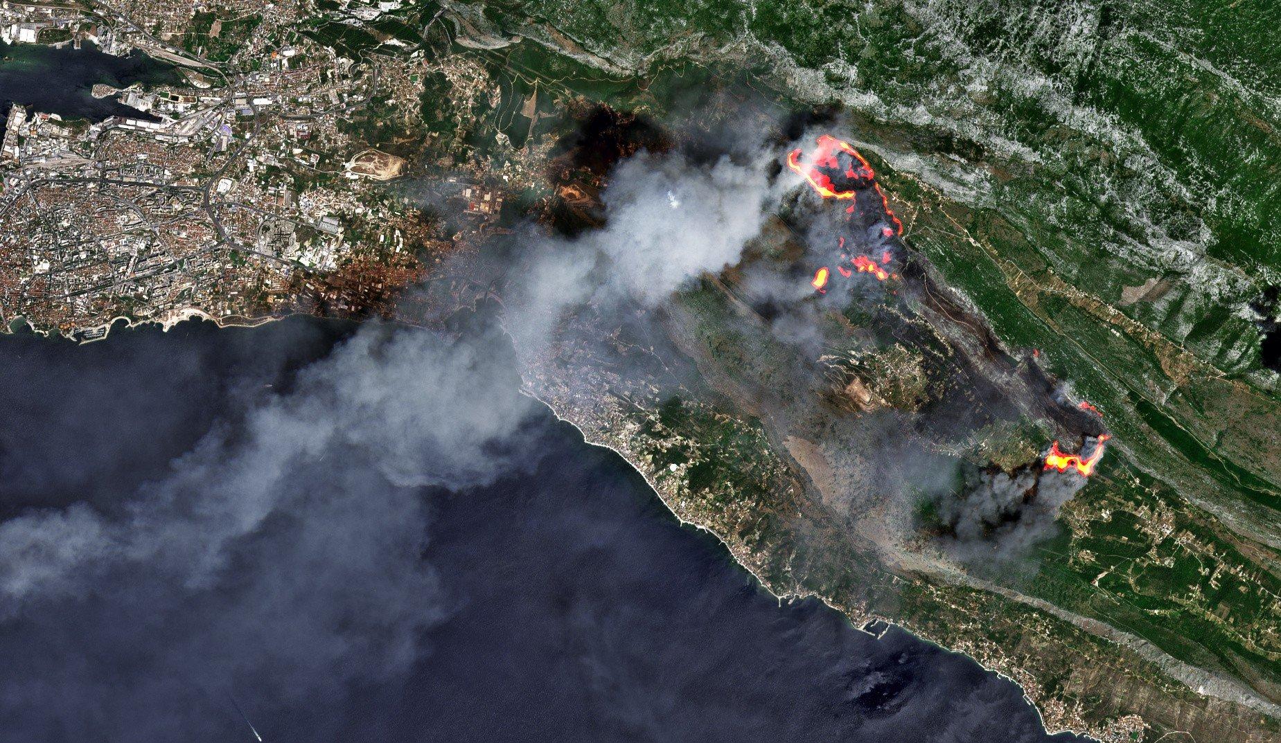
Archive image — wildfire east of Split, Croatia, observed by Sentinel-2 on 17 July 2017. QuickFire visualisation by Pierre Markuse for Sentinel Hub, reused under the CC BY-SA 4.0 licence.
In late July 2026, a succession of major wildfires transformed territories, mobility and forms of life across the Iberian Peninsula and France. In Spain, the speed and simultaneity of the fires in Villa del Prado, San Martín de Valdeiglesias and Burgohondo led the Ministry of the Interior to declare a national-interest emergency in the Madrid region and the province of Ávila on 23 July. Two days later, the declaration was extended to Toledo as the emergency crossed administrative boundaries and required the co-ordination of resources from several authorities.[1][2]
The crisis also activated European mechanisms. By 27 July, more than 300,000 people had been displaced by the fires in Spain and France. The European Union mobilised aircraft, helicopters, vehicles and personnel from several countries, alongside rapid emergency mapping from Copernicus.[3] Portugal and France had already requested European assistance in early July as several fires burned at the same time. Portugal received personnel and vehicles from Spain, as well as aircraft from the European reserve deployed by Italy and Spain.[4]
The French Interior Ministry updated its figures on 31 July. By then, 119,000 hectares had burned in France since the start of the year, while the Gironde fire had covered 42,000 hectares.[5] These figures belong to a particular moment in an evolving emergency rather than to a final account of the season.
Before that late-July escalation, the European Forest Fire Information System had recorded 254,388 hectares burned and 1,254 fires larger than thirty hectares across the European Union. The snapshot was dated 22 July. The page is updated weekly during the summer, and EFFIS warns that its figures may differ from national inventories because thresholds and methods vary. It also explains that burned areas are delineated by trained analysts working with satellite imagery and ancillary sources. The resulting maps combine remote observation with human interpretation.[6]
These numbers describe an emergency, but also a wider ecological transformation. Europe is the fastest-warming continent. Its temperature has risen by about 2.5 degrees above pre-industrial levels, and its rate of warming is more than twice the global average.[7]
Fire cannot be understood solely as a meteorological accident. Global heating encourages extreme temperatures, prolonged drought and more dangerous conditions for fire spread. Those conditions act upon territories transformed by agricultural abandonment, the expansion of settlements into fire-prone land, the accumulation of combustible material and certain forms of homogeneous forestry.
The European Environment Agency distinguishes rural land abandonment from planned ecological restoration. It also notes that diverse forests and heterogeneous landscape structures can interrupt fuel continuity and improve resilience. Agroforestry, adapted grazing, agricultural mosaics and the conversion of monocultures into mixed stands are among the measures considered.[8]
Within this setting, artificial intelligence is becoming increasingly visible. Cameras, sensors, drones, satellite images and predictive models promise to detect smoke, map perimeters, locate hotspots, anticipate risk or allocate resources.
Yet not all these instruments use artificial intelligence.
A thermal camera may register temperature differences without machine learning. A drone may transmit images without interpreting them algorithmically. A satellite may provide crucial information without relying on a neural network. Conflating sensing, automation and artificial intelligence produces a discursive inflation in which every technical upgrade is presented as AI, making it harder to assess what each technology actually contributes.
What artificial intelligence can contribute
The European Commission has made AI-assisted modelling one of the priorities of its new integrated approach to wildfire risk management. The strategy covers prevention, preparedness, response and recovery. It also proposes further development of EFFIS and European risk-modelling capacity, including priority for AI-assisted wildfire modelling tools.[9]
France is testing projects that make explicit use of artificial intelligence. MULTIFIRESCAN places multispectral sensors aboard light aircraft. An integrated AI engine processes the imagery, geolocates fire perimeters and hotspots, and generates operational maps at intervals of roughly fifteen to thirty minutes. During trials in Hérault, the system monitored more than one million hectares, accumulated 125 flight hours and detected ten ignitions before major spread occurred.[10]
CONDOR combines a long-endurance solar-powered drone with optical sensors and automated image analysis. Trials in the Pyrénées-Orientales showed that the system could detect fires in under five minutes. They also revealed sensitivity to strong winds and a higher rate of false positives than expected. The project recommends further refinement of the algorithm, operational procedures and regulatory framework.[11]
Spain has strengthened surveillance with high-capacity drones, thermal cameras and advanced digital tracking systems. Official documentation does not claim that all these devices use AI. It is more accurate to describe them as a technical infrastructure within which systems for classification, prediction or decision support may be integrated.[12]
In research, IberFire provides a daily spatio-temporal dataset at one-kilometre resolution. It covers December 2007 to December 2024 and integrates information on fire occurrence, weather, topography, vegetation, land use, human activity and location. Its use of open sources supports reproducible research on machine learning and wildfire risk.[13]
CFMap draws on IberFire data to generate monthly risk maps using a deep convolutional neural network. Its experimental results outperformed several conventional models and other deep-learning architectures. This demonstrates statistical performance within the study, not yet operational effectiveness during a real suppression or evacuation effort.[14]
Another recent study combines explainable AI with multi-objective optimisation to examine resource allocation under fixed staffing constraints. Its case study uses data from Taiwan and does not validate the framework for European territories. Its value lies in showing how recommendations change when speed, territorial balance or expected damage reduction receive different weights. Resource allocation always embeds choices about which risks and needs deserve priority.[15]
These technologies can provide valuable information. Gaining a few minutes during an ignition, locating a hotspot obscured by smoke or rapidly sharing an updated perimeter may help protect lives.
The public evidence reviewed here does not support attributing control of the July fires to any autonomous AI system. The best-documented projects remain experimental or complementary tools. Effective response still depends on firefighting personnel, forest services, communications, roads, available equipment and practical knowledge of each territory.[3][10][11]
Two timescales that must coexist
Effectiveness during an emergency and long-term ecological sufficiency operate on different timescales.
During a fire, minutes may be decisive. Responders need information that is rapid, intelligible and sufficiently reliable. Evaluation must consider detection speed, false positives, missed fires, verification time and the material capacity to act.
Prevention works over years and decades. It depends on land use, the maintenance of roads and water points, vegetation management, viable rural economies, planning policy, climate action and stable public services.
Recognising this difference avoids a false opposition. Immediate efficiency can save lives, while ecological sufficiency can reduce the continuing production of risk. Trouble begins when investment in technological response displaces prevention or is presented as a substitute for territorial transformation.
A forest made legible to the machine
Every model must select variables. To calculate risk, it may classify vegetation as fuel, terrain as slope, a dwelling as an exposed asset and a population as a vulnerability score.
These categories are operationally useful, but they do not exhaust what they represent.
A forest also contains property relations, family memories, common rights, grazing routes, forestry labour, animals and knowledge acquired over generations. An oak woodland, a densely planted pine stand and an abandoned agricultural mosaic may produce similar values in some datasets while embodying profoundly different social and ecological histories.
Beatriz Santamarina has reconstructed the ecological, symbolic and political traditions through which anthropology has approached the environment. Her work shows that the division between nature and culture is not a universal fact, but a historical way of ordering the world.[16]
Vanessa Monfrinotti examines that division as part of the political ontology of Western modernity. Nature is produced as an external realm available for observation, accounting and administration.[17]
Applied to computation, this critique shows that a model does more than represent a forest that already exists. It also participates in producing a particular version of that forest. It determines what can become data, which relations receive weight and which forms of knowledge remain outside the system.
A map may display humidity, biomass, wind and distance from homes. On its own, it cannot explain why grazing disappeared, how ownership became fragmented, which conflicts shape land use or why a district lost public services.
Fire among the ruins of progress
Anna Lowenhaupt Tsing helps us understand wildfires within landscapes produced by histories of extraction, abandonment and capitalist transformation. In The Mushroom at the End of the World, ruins are not empty spaces left after disaster. They are places where ecological relations, precarious labour and unexpected forms of collaboration and survival continue to emerge.[18]
The forests burning in Spain, Portugal and France are not outside human activity either. They have been shaped by reforestation, monocultures, agricultural abandonment, dispersed urban development, tourism, grazing, conservation policy and timber markets.
When a model calculates risk across these landscapes, it processes the accumulated outcome of historical decisions. Those decisions, however, tend to reappear as apparently neutral present conditions.
Agricultural abandonment becomes fuel load.
Depopulation becomes a lack of surveillance.
Property development becomes exposure.
Precarity becomes vulnerability.
Jason W. Moore uses the Capitalocene to shift responsibility away from an abstract humanity and towards historical arrangements of capital, labour, energy and nature. Ecological crisis has not been produced equally by all people, companies, institutions or territories, and its consequences are not distributed equally.[19]
An application may identify the driest plot, but it cannot explain the economic conditions that removed the practices which once kept the land open. It may recognise exposed homes, but it does not necessarily show who has access to a car, insurance, mobile coverage or somewhere else to stay.
The anti-politics machine
James Ferguson showed how certain interventions turn historical conflicts and power relations into apparently technical problems. His idea of the anti-politics machine describes how an administrative intervention may hide the political dimensions of a situation while expanding bureaucratic forms of management.[20]
Artificial intelligence may perform a similar function when rural abandonment becomes a fuel layer, understaffing becomes an optimisation problem or social inequality becomes a vulnerability score.
The variables may be correctly calculated while the overall representation remains inadequate.
Investment in sensors creates a highly visible image of innovation. Sustaining forestry work, extensive grazing, road maintenance, agricultural mosaics and rural services over many years has less technological spectacle, even when it may alter the flammability of the landscape more profoundly.
Technology can improve suppression and strengthen prevention. It can also legitimise a model centred almost entirely on reaction once the territory is already burning.
A territorial assemblage
Actor-network theory helps us move beyond the image of the algorithm as an autonomous entity. Technologies work through associations among people, knowledge, institutions, rules, infrastructures and objects.[21]
A prevention and response system is made up of satellites, sensors, weather models, suppliers, co-ordination centres, telecommunications networks, firefighting teams, roads, budgets, vegetation, water and atmospheric conditions.
When an alert fails to produce an adequate response, the problem may lie in the sensor, connectivity, automated classification, interface, verification protocol or absence of available resources. A prediction may also be accurate while evacuation remains impossible because roads are congested or adapted transport is unavailable.
Evaluating AI requires examining the whole assemblage. Model quality matters, as does the capacity to act afterwards. So do data ownership, public procurement, the possibility of audit and the distribution of responsibility when a recommendation proves wrong.
The care missing from the dashboard
During an evacuation, much of the essential work takes place beyond technological command centres. People move animals, host those who have temporarily lost their homes, prepare food, share medicines and accompany others through fear and uncertainty.
Susana Narotzky has shown how care and social reproduction are sustained through obligations, affections and forms of labour that are often hidden from economic accounts. Her approach helps us see that emergency response also relies on family and community infrastructures distributed unequally across society.[22]
A model can calculate how many people live in a risk zone. It has far greater difficulty representing who cares for whom, which households can travel, who depends on medication or who will later take on cleaning, animal care and the reconstruction of everyday life.
These networks do not replace public responsibility. They require services, resources and institutional protection. Their absence from dashboards does not make them secondary. They form a central part of the collective capacity to endure an emergency.
Self-restraint against technological solutionism
Jorge Riechmann adds a decisive ethical and political orientation. His proposal of simbioética, or symbioethics, places human life within networks of dependence and mutual transformation. People do not live opposite an external nature. We exist inside communities of life that make our own continuity possible.[23]
This perspective introduces the principle of self-restraint. An ecologically responsible technology cannot be evaluated only through speed or efficiency. Its purposes, scale, material requirements, energy use and effects on ecological relations must also be examined.
AI may improve one part of wildfire response. It cannot compensate for an economy that intensifies heating, fragments territories and maintains consumption levels incompatible with biophysical limits.
Riechmann presents collective self-limitation as a condition for the existence of other people and other living beings. This is not a rejection of innovation. It demands democratic discussion about which technologies are needed, for what ends, at what scale and under whose control.[24]
This criterion shifts attention from isolated efficiency towards sufficiency. One technology may consume fewer resources than another while remaining part of an unsustainable expansion of material throughput. It may improve detection while economic and territorial policy continues to produce ever more dangerous conditions.
Self-restraint establishes a political order of priorities.
Climate mitigation must reduce the structural causes of heating.
Territorial management must recover diverse and habitable landscapes.
Public services, forestry employment and networks of care require continuity.
Technology may support these tasks, but it should neither replace them nor determine their ends.
Symbioethics also expands what counts as the protected population. Wildfires do not destroy only human property and infrastructure. They damage soils, refuges, breeding grounds, microorganisms, vegetation and ecological relations whose recovery may take decades.
Giving institutional form to territorial intelligence
A common territorial intelligence needs more than general principles. It requires institutions, procedures, resources and the capacity to handle conflict.
Authorities responsible for civil protection and forestry could establish permanent territorial bodies involving emergency services, local councils, forestry professionals, rural communities, environmental organisations, research centres and representatives of farming and grazing activities.
Such bodies should not merely approve systems after purchase. They should intervene before procurement, during the selection of variables and throughout subsequent evaluation.
Public contracts could require documented models, version histories, information about training data, territorial testing and periodic publication of false positives, omissions and response times. The protection of genuinely sensitive data should not become a justification for hiding the criteria through which public resources are distributed.
Local validation should take place through simulations and field exercises. Model outputs should be compared with the experience of firefighting personnel and the knowledge of those who work on the land. Disagreements should be recorded, debated and used to modify the system.
Participation does not remove conflict. Forest owners, grazing communities, public authorities, technology companies and environmental movements may defend different interests. Territorial intelligence should not pretend that consensus already exists. It should create democratic procedures that make disagreement visible and allow public decisions to be made.
Warning systems also require redundancy. Mobile applications and automated messages must coexist with radio, local media, audible warnings, face-to-face contact points and organised neighbourhood networks. A safety infrastructure dependent on a single digital channel may exclude people without coverage, battery power, digital skills or continuous access to a device.
Evaluation should include both effectiveness and equity. Counting detected fires is not enough. Authorities should also examine which territories accumulate errors, which populations receive warnings later, which resources are available after an alert and who bears the costs of a wrong decision.
Staying with the trouble
Donna Haraway asks us to stay with the trouble of a damaged Earth rather than seek an external position from which total solutions can be offered. Her work understands nature as a biocultural articulation and calls for situated responses among interdependent species and communities.[25]
From this position, AI ceases to appear as an intelligence arriving from outside to save the forest. It becomes a situated tool within ecological, economic and political relations that must be cared for and transformed.
This summer’s wildfires show both the usefulness and the limits of predictive technologies. Earlier smoke detection, rapid perimeter mapping and shared information can protect lives.
It would be equally irresponsible to trust that better models can compensate for abandoned landscapes, more extreme climatic conditions, territorial inequality and public services under pressure.
The intelligence most needed may be the capacity to combine different forms of knowledge without subordinating one to another.
A public and territorial intelligence connecting satellites with grazing, thermal cameras with local memory, weather prediction with neighbourhood networks, ecological restoration with climate justice, and technical capacity with self-restraint.
AI may help us see the fire sooner.
Preventing Europe from becoming an increasingly flammable territory requires changing what the model can barely represent.
Institutional and scientific sources
[1] Spanish Ministry of the Interior. 2026. Order INT/748/2026 of 23 July. Boletín Oficial del Estado, 24 July 2026.
[2] Spanish Ministry of the Interior. 2026. Order INT/762/2026 of 25 July. Boletín Oficial del Estado, 26 July 2026.
[3] European Commission. 2026. The EU sends planes and firefighters as wildfires ravage France and Spain. 27 July 2026.
[4] European Commission. 2026. EU deploys wildfire support to face multiple fires across Portugal and France. 6 July 2026.
[5] Ministère de l’Intérieur. 2026. Sur terre et dans les airs — combattre le feu sur tous les fronts. Updated 31 July 2026.
[6] Joint Research Centre. 2026. Current wildfire situation in Europe. Data updated 22 July 2026.
[7] Copernicus Climate Change Service and World Meteorological Organization. 2026. Why is Europe warming so quickly?. European State of the Climate 2025.
[8] European Environment Agency. 2025. Nature-based solutions for fire-resilient European forests. DOI 10.2800/8810870.
[9] European Commission. 2026. Modernising our approach to tackling the rising wildfire threat. 25 March 2026.
[10] Direction générale de la Sécurité civile et de la gestion des crises. 2026. MULTIFIRESCAN.
[11] Direction générale de la Sécurité civile et de la gestion des crises. 2026. CONDOR.
[12] Government of Spain. 2026. 2026 wildfire campaign. 21 May 2026.
[13] Ercibengoa, Julen, Meritxell Gómez-Omella and Izaro Goienetxea. 2025. IberFire — a spatio-temporal dataset for wildfire risk assessment in Spain. Version 0.2.
[14] Lopes, Lucas, Rafik Ghali and Moulay A. Akhloufi. 2026. CFMap — A Deep Convolutional Neural Network for Predicting Wildfire Risk Maps. ISPRS Annals of the Photogrammetry, Remote Sensing and Spatial Information Sciences XI-3-2026, 173–178.
[15] Hsu, Bin-Wei. 2026. Integrating explainable AI and multi-objective optimization for wildfire resource allocation under fixed staffing constraints. Scientific Reports 16, 20059.
Theoretical references
[16] Santamarina Campos, Beatriz. 2008. Antropología y medio ambiente. Revisión de una tradición y nuevas perspectivas de análisis en la problemática ecológica. AIBR. Revista de Antropología Iberoamericana 3, 2, 144–184.
[17] Monfrinotti Lescura, Vanessa Ivana. 2021. El trasfondo ontológico de la modernidad occidental. Revisión crítica de la escisión naturaleza/cultura. En-Claves del Pensamiento 30, e422.
[18] Tsing, Anna Lowenhaupt. 2021. La seta del fin del mundo. Sobre la posibilidad de vida en las ruinas capitalistas. Translated by Francisco J. Ramos Mena. Capitán Swing. Original English edition published in 2015.
[19] Moore, Jason W. 2020. El capitalismo en la trama de la vida. Ecología y acumulación de capital. Translated by María José Castro Lage. Traficantes de Sueños. Original English edition published in 2015.
[20] Ferguson, James. 1994. The Anti-Politics Machine. Development, Depoliticization, and Bureaucratic Power in Lesotho. University of Minnesota Press.
[21] Tirado, Francisco J. and Daniel López Gómez. 2012. Teoría del actor-red. Un pragmatismo contemporáneo. In Teoría del actor-red. Más allá de los estudios de ciencia y tecnología, 1–17. Amentia.
[22] Narotzky, Susana. 2008. La renta del afecto. Ideología y reproducción social en el cuidado de los viejos. In Paz Moreno Feliu, ed., Entre las gracias y el molino satánico. Lecturas de antropología económica, 321–336. UNED.
[23] Riechmann, Jorge. 2022. Simbioética. Homo sapiens en el entramado de la vida. Plaza y Valdés.
[24] Riechmann, Jorge. 2022. Autolimitarnos para que pueda existir el otro. Sobre energía y transiciones ecosociales. Papeles de Relaciones Ecosociales y Cambio Global 156, 11–25.
[25] Haraway, Donna J. 2016. Staying with the Trouble. Making Kin in the Chthulucene. Duke University Press. DOI 10.1215/9780822373780.
Image credit
Pierre Markuse. 2022. Wildfire visualization. Representative image of the wildfire east of Split, Croatia, acquired by Sentinel-2 on 17 July 2017. QuickFire visualisation for Sentinel Hub, reused under the CC BY-SA 4.0 licence. Contains modified Copernicus Sentinel data [2017].